Tuesday, 30 June 2015

The best place for a rail fan on Earth?


(All pics 23.6.2015 copyright Steve Sainsbury/Rail Thing)


I always assumed the closest thing to rail heaven (if your interest extends to trams and narrow gauge!) would be somewhere in Switzerland, perhaps Aigle or Interlaken Ost, or possibly Wales (Porthmadog or Llanberis) but I think I've found it in Italy of all places!!

Porta Maggiore is a stop on four of the city's tram routes, but also on the 950mm suburban line to Giardinetti and with the busy main line into Roma Termini as a backdrop. The whole area is intersected by a number of Roman aqueducts and the trams and trains happily thread through the arches. The whole area is so busy that there seems to always be at least one thing moving, often more!
The narrow gauge line seems to have a constant procession of yellow and white trains intersecting the whole site, cutting across tram tracks, through arches, past what appears to be a Roman temple and then across one of the busiest Rome streets (all completely unprotected of course!) and down a side street into the city centre.

Later in the week we went on a tram tour from here and in the evening the place is even better, busier and with nicer light. Well worth a visit even if trams and light railways aren't your thing!

Sunday, 28 June 2015

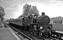
Dorking 1973


(All Dorking (North) 12.5.1973 Copyright Steve Sainsbury/Rail Thing)


As a kid I was often driven up to London and always looked out around Dorking for trains as the railway from Horsham through Warnham to Dorking was visible as you approached Dorking and, intriguingly, a second line crossed the road almost where Dorking station was. I never once saw a train crossing that line, but saw a few working their way up through Boxhill (which always seemed a strange place to have a station).

Into the 70s I was getting around on my own, by train of course. Back in 1973 I finally got to visit the station at Dorking, which I then knew was just one of three stations that served Dorking. It was full of boring slam doors of course - that's how we thought about them back then! The station itself was quite a large and attractive building and had a mix of suburban and through trains. The line south to Horsham was lightly used back then with some interesting intermediate stations.

A short walk took me to that other line, the one which crossed the A24 rather than paralleled it. I knew by 1973 that it was a dieselised cross country route between Reading and Tonbridge with some interesting cross-regional traffic. Just as I climbed the stairs and had taken my first shot of the station a coupled pair of class 33s came through. I was about eight years too late for steam but back then diesels were almost as big a treat!


(Both Deepdene 12.5.1973 Copyright Steve Sainsbury/Rail Thing)

More info (via Wikipedia - Dorking (North))

Dorking railway station is one of three railway stations that serve the town of Dorking in SurreyEngland. The station is within walking distance of Dorking Deepdene station and interchange on a through ticket is permitted. Dorking West and Dorking (Deepdene) are located on the North Downs Line.
There are 2 trains per hour (tph) towards London Waterloo, 2tph towards London Victoria and an hourly service to Horsham(Monday to Saturday off-peak). South West Trains services to London Waterloo typically use Platform 2. Southern services to Horsham generally depart from platform 3.
The station which was previously called Dorking North was rebuilt during the 1980s and is now part of the same office block which houses the headquarters of Biwater.
Ticket barriers were installed in 2010.

Construction

The Mole Gap between Dorking and Leatherhead is one of the few natural breaches in the North Downs and its potential as a rail corridor was realised as early as 1830 when a line linking London to Brighton was proposed. In 1845-6, the "Direct London and Portsmouth Railway" was authorised by parliament to run south from Epsom to Dorking on to GodalmingHavant and Portsmouth. The scheme failed to attract sufficient investment and was dropped in favour of the WokingGuildford and Havant route fromLondon Waterloo.
The first railway line to link Dorking with London was the independently promoted "Reading, Guildford and Reigate Railway" proposed in 1845-6, authorised by Acts of Parliament in 1846 and 1847. This became the line we know today as the North Downs Line.
By 1859 the LBSCR and LSWR had built a joint line to Leatherhead from Epsom where their tracks separated (the former heading for London Bridge the latter for London Waterloo. An independent Horsham, Dorking and Leatherhead Railway was set up and promoted by interested local parties (principally from Horsham) to link the three towns. The railway was approved by Act of Parliament in July 1862, but only from a junction with the North Downs Line, 100 yards (91 m) to the east of Dorking Deepdene, to the Arun Valley Line at Horsham.
A year later in July 1863 LBSCR secured authority to build the line from its station at Leatherhead to make a connection with the line from Horsham. The line to Leatherhead was opened on 11 March 1867, however the connection with the line from Horsham was not made until 1 May 1867. Initially services ran from London Bridge to Brighton via Sutton and Steyning four times per day in each direction.

Electrification

The Southern Railway, formed in 1923, began an extensive programme of electrification of their suburban lines. The line from Waterloo to Dorking was electrified using the 660V third rail system in 1925 and regular half-hourly semi-fast services were introduced on 12 July 1925 to run seven days per week. The 22.5 mi (36.2 km) journey to Waterloo originally took 45 minutes, although this was considerably lengthened when trains began to stop at all stations shortly afterwards. An additional hourly electric service to London Bridge via Mitcham Junction and Tulse Hill began on 3 March 1929; the 25 mi (40 km) journey took 53 minutes.
The mid-Sussex electrification of 1938 resulted in the express steam services from Victoria being replaced by electric services which were routed through Dorking. These gave commuters from Dorking their fastest ever link to Victoria (34 minutes during peak hours). In the timetable change of May 1978 the mid-Sussex express services were routed via Gatwick Airport and the off-peak service to Dorking was reduced to two semi-fast services from Victoria per hour, with services to Horsham running every two hours. Now the average journey time to London termini takes a passenger 55 minutes.
The service to Horsham was neglected for some years during the 1980s with a shuttle service between Dorking and Horsham operating every two hours at off peak times. The service now provided is one train an hour through from London to Horsham, (headcode 84). The off peak service of two trains from London Bridge to Horsham via Sutton and Dorking ran for a number of years from about 1985 but had ceased by 2000. The former Horsham to Waterloo via Dorking North trains (headcode 15) ceased as early as 1980.

Signal box

The resignalling scheme of 1938 introduced three aspect colour signals to replace the original semaphore signals. A new signal box was constructed and opened on 15 May 1938. It is one of many built in the Odeon style by the Southern Railway during the 1930s. The original frame was an A2 type Westinghouse with 44 levers. The box controls the line from Box Hill & Westhumble to Warnham.

More info - (from Wikipedia (Deepdene))

Dorking Deepdene railway station is in DorkingSurrey, England.
The station and all trains serving it are operated by First Great Western. It is on the North Downs Line. It is one of three stations in Dorking. The other two are Dorking and Dorking West. The station is within walking distance of Dorking station and interchange on a through ticket is permitted.
There is no ticket office and the station is unstaffed. Tickets can be bought on trains or from the automatic ticket machine at the foot of the westbound platform stairs. The ticket office at Dorking station is open seven days a week and sells tickets for all National Rail services. The station is accessed by steps only and as such there is no disabled access to either platform.

History

The Reading, Guildford and Reigate Railway (RG&RR) was authorised in 1846 and opened in stages. One of the first parts to open was between Redhill and Dorking, on 4 July 1849; the terminus was the present Dorking West station.
Redhill - Reading train in 1964
A second station in Dorking was opened on 1 February 1851 on the same route, and was originally named "Box Hill and Leatherhead Road"; this was shortened to "Box Hill" in March the same year. The RG&RR was soon absorbed by the South Eastern Railway (SER).
The station at Box Hill was temporarily closed from 1 January 1917, and reopened on 1 January 1919.[2] In the 1923 grouping the SER became part of the new Southern Railway, which on 9 June of that year renamed the station "Deepdene" to avoid confusion with Box Hill & Westhumble station.
On 11 May 1987 British Railways renamed the station "Dorking (Deepdene)".

Services

The typical off-peak service is two trains per hour to Reading, and two to Redhill, of which one continues to Gatwick Airport.

Saturday, 27 June 2015

Mid Sussex 1977


(All pics copyright Steve Sainsbury/Rail Thing Amberley 20.5.1977)


When I was growing up in Littlehampton in the 60s and 70s we had two ways of getting to London - on the semi-fasts via Hove and Haywards Heath, or on the more direct (if slightly slower) Mid Sussex route. Whenever I could I chose the Mid Sussex. It runs through lovely Sussex countryside on the stretch between Arundel and Pulborough, with the Downs visible the whole time. And about midway is the station at Amberley (actually in Houghton). Now better known as the home of the Amberley Museum back in 1977 when these photos were taken there was little more than a tea room near the station.

The station has changed a bit - it was affected by a fire, the trains have changed and there's no longer a signalbox! But the views are still there - and of course you've a great reason to go now as it's the best way to get to the museum, which has a working narrow gauge railway as well as many other transport related exhibits.

More info (from Wikipedia)

Amberley railway station is a railway station in West SussexEngland. It serves the village of Amberley, about half a mile away, and was opened by the London, Brighton and South Coast Railway. The Amberley Working Museum – a museum of industry – is accessed from the former station goods yard.
The station is 55 miles (89 km) south of London Victoria railway station on the Arun Valley Line.

History

Opened by the London, Brighton and South Coast Railway, it became part of the Southern Railway during the Grouping of 1923. The station then passed on to the Southern Region of British Railways on nationalisation in 1948.
When Sectorisation was introduced in the 1980s, the station was served by Network SouthEast until the Privatisation of British Railways.
A signalbox is situated on Platform 2 under the station canopy.

Services

There is an hourly service in each direction, northbound to London Victoria and southbound to Bognor Regis.
All trains are operated by Southern, usually using Class 377 trains.

Wednesday, 24 June 2015

Roaming Roman Rails


9250 Rome 17.6.2015


9023 and 9250 Rome 17.6.2015


9116 Flaminio Rome 17.6.2015


Ostia train at Roma San Paolo 19.6.2015


423 Porta Maggiore 20.6.2015


7021 Coloseo 22.6.2015

(All pics copyright Steve Sainsbury/Rail Thing)


Just returned from my first visit to Rome. Fantastic in many ways and also plenty for rail and tram enthusiasts, with a lot more promised in the future! Highlights were a trip to the Vatican in a huge thunderstorm which stopped the trams for a while, urban street running narrow gauge, the tram by the Colosseum and the best of all, the Jazz Tram. Low point was the disgusting state of the line to Ostia, Rome's port. More to follow on all of this and more - still recovering at the moment!


Sunday, 14 June 2015

Leadhills and Wanlockhead Railway


(Both pics copyright Steve Sainsbury/Rail Thing Leadhills 1990)


The closest I've ever lived to a heritage line was during my five years living in Leadhills, Scotland. Leadhills in Lanarkshire is Scotland's second highest village, the highest, Wanlockhead in Dumfries and Galloway, is just over a mile away.

Until 1938 both villages were served by a light railway that linked them to the West Coast main line at Elvanfoot. As its name suggests Leadhills had several lead mines, as did Wanlockhead. There were also small quantities of gold in the local streams. The railway allowed passengers to join and alight from the trains at any point. 

At between 1400 and 1500 feet above sea level both villages tend to get a lot of snow in winter, in fact it proved almost impossible to photograph the line in winter without there being snow on the ground!

Many years after the line closed a group was formed to build a 2 foot gauge line between the two villages. Progress has been slow thanks to the line crossing the county boundary, and at the moment the track stops in a bleak cutting exactly on the border between Lanarkshire and Dumfriesshire. Dumfries does support the line and the plan is to eventually connect to Wanlockhead and its fantastic Museum of Lead Mining. There were many other narrow gauge tramways in the hills, if you know where to look there is still some gtrack in situ, and there was even a funicular in the biggest mine, which took miners to the lower shafts.

As well as the railway closing the villages themselves were the subject of a closure order in the 1960s, and were in danger of being evacuated and abandoned. Luckily that didn't happen and both villages are now thriving and fascinating places! The line opens at weekends in the summer and a trip should be combined with a trip to the museum, and even a spot of goldpanning.

More info (via Wikipedia)

The Leadhills and Wanlockhead Light Railway was a short branch railway built to serve mining settlements, high in the Lowther Hills, connecting them to the Carlisle - Carstairs main line. The line was opened in 1901 - 1902, and was the highest standard gauge railway line in the British Isles. Hoped-for developments did not emerge, and when the world lead price slumped in the 1920s, the line sustained heavy losses. It was closed at the end of 1938.

History

System map of the Leadhills and Wanlockhead Light Railway
The Light Railways Act 1896 was introduced to encourage the cheap construction of railways that were likely to be lightly used, by permitting some of the former requirements for new railway construction to be omitted.
Lead had been mined in the wild terrain at Leadhills since the eighteenth century; it was carted to Leith Harbour via Biggar over the poor roads of the period. 80% of Scotland's output came from the area. In 1845 a narrow gauge tramway was built between Meadowfoot, about 3 miles (4 km) west of Wanlockhead to bring the lead ore (Galena) up to Wanlockhead for smelting. Other mines and a washery at Leadhills were also connected.
Local promoters saw that a railway connection to the main line would encourage the mining activity, and possibly also stimulate the establishment of a health resort there.
The Leadhills and Wanlockhead Light Railway obtained its authorising light railway order on 5 August 1898, to make a branch from Elvanfoot, on the main line of the Caledonian Railway. The line opened as far as Leadhills on 1 October 1901 and was extended to Wanlockhead on 1 October 1902. It was worked by the Caledonian Railway.
Lead mining traffic was carried, but was never as extensive as hoped, and the health-seeking visitor traffic was scant: the line dragged on with a very thinly patronised train service for less than 40 years. The Wanlockhead Mining Company went into liquidation in 1936, following a slump in world lead prices after World War I, and the viability of the line was finished.
The line closed to passenger traffic on 31 December 1938, and to goods shortly afterwards.

The line[edit]

When the line opened as far as Leadhills, that station was the highest in Scotland and the following year Wanlockhead took that accolade, at 1,498 feet (457 m) above sea level. The line was the highest standard gauge line in the British Isles, and also the highest adhesion-worked line. The altitude at Elvanfoot is 922 feet (281 m) and the length of the line was 7¼ miles (11.7 km); the average gradient was 1 in 42.
The only stations were Elvanfoot, the junction station on the main line, and Leadhills and Wanlockhead. The passenger stations did not have raised platforms, and the passenger carriages had three levels of step board which folded down to enable passengers to board. The Caledonian Railway worked the line, and no 172, an 0-4-4T was used in the early years. The trains were mixed (passenger and goods) and the maximum speed was 20 mph (32 km/h).
Rispin Cleugh viaduct shortly before being demolished, 11 November 1990
A significant structure on the line was Rispin Cleugh viaduct, built by Sir Robert McAlpine & Co. It was built from concrete and was clad with terracotta bricks to improve its appearance. It was demolished with explosives in 1991.
The tramway referred to was intersected by the railway when it was built, and there was a flat crossing a short distance north of Leadhills station, where the tramway led to a washery.

Reuse

The narrow gauge Leadhills and Wanlockhead Railway, which is also a light railway, has been built on the track formation, west from Leadhills. Some terracotta bricks from the demolished viaduct were used to clad a signal box at Leadhills station.

Saturday, 13 June 2015

Abingdon 1985


(All 30.5.1985 copyright Steve Sainsbury/Rail Thing)


On a sunny evening in 1985 I visited Abingon for the first and only time, and found the branch still in situ. Unfortunately the late evening light made photography quite challenging but I did get these six shots.

The line closed to passengers in 1963 robbing this busy town of a modern transport link, but the line stayed open to freight until the 1980s. I'm sure it was closed completely in 1985 when I took these photos, but I may well be wrong! I haven't yet found a date for complete closure.

As always you have to wonder why a town of this size lost its trains. Commuters would no doubt be very grateful for a rail service to London and beyond now. Perhaps many of these shorter branch lines will reopen as narrow gauge electrified routes in the future, though I'm sure many would work just as well as standard gauge lines, providing an essential link once roads are no longer an option.

More information (from Wikipedia)

History

The station was built by the Abingdon Railway, although this was operated by the Great Western Railway (GWR) from opening on 2 June 1856. The station and yard were built to the broad gauge on land acquired from the Mayor and Aldermen of the Borough of Abingdon on 19 March 1856 at a cost of £472. Seven properties were demolished to make way for the station and yard, including the Plough Inn which was subsequently rebuilt at a different location. The approach to the station from Stert Street had gates and no public right of way was allowed. Station facilities consisted of a single platform covered by a timber train shed.[1] A locomotive shed was built on land which was never formally conveyed to the railway, but later acquired by adverse possession.
The Abingdon Railway was absorbed by the GWR on 15 August 1904. The line passed on to the Western Region of British Railways on nationalisation in 1948, and was then closed to passengers by the British Railways Board in 1963. However the branch was used by freight, notably MG Cars, and the occasional passenger excursion, the last of which took place in June 1984.
The branch track was lifted in the late 1980s.

Sunday, 7 June 2015

Clevedon surprise


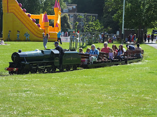
(All 7.6.2015 copyright Rail Thing/Steve Sainsbury)


The sun drew us out to Clevedon today. Now Clevedon once had four stations, one on the short GWR branch from Yatton, and three on the fantastic Weston, Clevedon and Portishead Railway. Today there are no standard gauge stations (unbelievably for such a busy town) - but we did find one station, still busy and with trains running ....

My last trip to Clevedon was in 2007 and I found what looked like a 10 1/4" gauge line by the seafront. Today the line is still there but has been regauged to 15" - and what a nice set up it is! There is a very smart loco, which to my untrained eye is a scaled down model of an actual class from the standard gauge (I don't really do the loco thing!) and the route still runs around the perimeter of the common, which today was really lively with picnics, donkey rides and a bouncy castle, so plenty to see!

Clevedon of course really needs its branch back - it closed in 1966, stupidly in my opinion as it was only a short route and was busy to the end. Doubtless many commuters parked at Yatton and took the train from there, but doubtless many more just stayed in their cars and endured the drive into Bristol. All seaside towns need trains, and they really need to be coming into the heart of town again. I also happen to think that a revived WCPR would be a fantastic asset to Weston, Clevedon and Portishead and hope one day to be able to travel from Bristol to Weston via the reopened Portishead line (opening in 2018) and on to Weston via the WCPR!


Wednesday, 3 June 2015

Bristol Temple Meads 1.6.2015


Surviving tram tracks at the station approach.


66 507


150 123


150 123


66 516


(All copyright Steve Sainsbury/Rail Thing 1.6.2015)


Another hour or so at Bristol Temple Meads on the 1st of June, an hour or so later than I'm usually there. Took the opportunity to snap the surviving tram tracks on the station approach as whispers and buzzes about trams for Bristol are getting louder!

There was a class 66 parked nicely at the north end of the station so I got some shots of that - first time there's been a light engine around whilst I've been later. Had the added bonus of another 66 on a Freightliner heading north - and as it just got out of a shot a second freight was also heading north behind a class 70. Had I not been feeling rough, and/or a bit more sprightly, I could have raced along the platform a bit and got a shot of 3 locos in frame - but it was not to be!

So Temple Meads is still in a state of pre-change, no sign of electrification yet.

As an aside after meeting my son on the station we went into town not by bus or taxi (or on foot) but by boat courtesy of the brilliant Bristol Ferry Company which offer a commuter service right into the heart of the city which at £2 must be one of the best transport bargains in the UK - highly recommended!